Planning and Policy Framework
The full Strategic Flood Risk Assessment report and Strategic Flood Risk Assessment Addendum created by Metis Consultants Ltd is available to download from our website.
2.1 Overview
This section provides an overview of the policies, requirements and strategic documents that are relevant to flood risk in Kingston. National, regional, and local level policy framework is outlined, all of which provide guidance for this SFRA.
Wherever possible, a hyperlink is provided for the referenced source material. Over time, the policies and documents referenced in this section may be superseded. Users of this document must keep up to date with any changes to ensure that development proposals are in line with current poli
2.2 National Policy
2.2.1 National Planning Policy Framework
The revised National Planning Policy Framework (NPPF) was published in February 2019 by the Ministry of Housing, Communities and Local Government (MHCLG), with an update issued in June 2019. It supersedes the previous NPPF which was published in March 2012 and revised in July 2018.
The document outlines the government’s planning policies for England and how these are expected to be applied. It provides a framework within which Local Planning Authorities (LPAs) can prepare plans for housing and other developments. It also provides guidance for prospective applicants for planning application submissions. The NPPF revisions have been completed with the aim of improving and updating the plan-making process.
The NPPF replaces Planning Policy Statements (PPS), creating a single document for all Statements. This includes ‘Planning Policy Statement 25 (PPS25) Development and Flood Risk,’ (updated December 2009) with all relevant planning information now included in the NPPF. Section 14 of the current NPPF covers the need to meet the “challenge of climate change, flooding and coastal change”. Paragraphs 155-165 specifically relate to “Planning and flood risk”. Paragraph 156 highlights the importance of an SFRA and the role they should play in planning and flood risk:
“Strategic policies should be informed by a strategic flood risk assessment, and should manage flood risk from all sources. They should consider cumulative impacts in, or affecting, local areas susceptible to flooding, and take account of advice from the Environment Agency and other relevant flood risk management authorities, such as lead local flood authorities and internal drainage boards.”
Paragraphs 157 to 164 of the NPPF outline the Sequential and Exception Tests as a means of steering new development proposals to areas at the lowest risk of flooding. This SFRA provides the basis for applying these tests. Guidance for the application of the Sequential and Exception Tests can be found in Section 6.
The NPPF features in the White Paper on Fixing our broken housing market (2017). The document introduces planning and housing market reforms, focusing on the concept of “Planning for the right homes in the right places”. Some of the key changes linked to planning and flood risk in the current NPPF include:
- Paragraph 156 – Cumulative flood risk impacts – Strategic and planning policy on flood risk should consider cumulative flood risk impacts from all sources.
- Paragraph 157 – Adjusting for climate change and flood risk impacts – Local Plans should consider the current and future impacts of climate change. If it is expected that climate change may lead to an increase in flood risk, resulting in some existing development being less sustainable in the long term, opportunities should be sought to relocate the development.
- Paragraph 165 – Sustainable Drainage Systems (SuDS) in major developments – Major developments should incorporate SuDS as part of their drainage scheme proposals unless proof can be provided that it would be inappropriate. The proposed SuDS should have appropriate minimum operational standards and provide multifunctional benefits where possible. Drainage proposals for major developments are assessed by Lead Local Flood Authorities (LLFAs) through their statutory consultee role as defined in Written Ministerial Statement HCWS161.
On 12 March 2020, MHCLG published ‘Planning for the Future’, a policy paper outlining government’s ambitions for housing and planning. The 12 March publication was accompanied by a statement from the Housing Secretary outlining ‘plans for the future to get Britain building’. Within this, government has outlined its commitment to publishing a revised NPPF. As part of government’s ‘green housing revolution’, the NPPF will also include a review of the policy for building in areas at flood risk, seeking to ensure that communities across the country know that future development will be safe from floods. Government will assess whether current flood safeguarding protections in the NPPF are enough and consider options for further reform. The NPPF should be reviewed periodically to ensure that the housing policy referenced in this document is current.
2.2.2 Flood Risk and Coastal Change Planning Practice Guidance
The ‘Flood Risk and Coastal Change’ section of the Planning Practice Guidance (PPG) was initially published in March 2014, and is intended to serve as a living document. Parts of the document have since been updated in accordance with the revised NPPF. The ‘Flood Risk and Coastal Change’ PPG operates in conjunction with the NPPF, defines flood risk and outlines certain Risk Management Authority (RMA) responsibilities for managing different sources of flooding.
It provides additional guidance and supporting information for LPAs on how to account for flood risk in preparation of the Local Plan and detail on what should be included as part of an SFRA. Specific detail is provided on how LPAs and applicants can assess, avoid, manage and mitigate against flood risk.
2.2.3 Flood and Water Management Act (2010)
The Flood and Water Management Act (FWMA) 2010 provides an improved and effective method of managing flood risk across England and Wales. The FMWA defines the roles and responsibilities of RMAs in England and Wales, the bodies who manage flood risk from different flood sources. The Act defines the EA, LLFAs, District Councils (where there is no unitary authority), Internal Drainage Boards, Water & Sewerage Companies and Highway Authorities as RMAs. As an LLFA, Kingston has several responsibilities under the FWMA:
- Developing, maintaining and applying a Local Flood Risk Management Strategy (LFRMS)
- Maintaining a flood risk asset register
- Managing the risk of flooding from local sources (surface water, groundwater and ordinary watercourses)
- Investigating and recording key local flood incidents
- Regulation of works on ordinary watercourses
- Sharing of information about flood risk
2.2.4 Flood Risk Regulations (2009)
The Flood Risk Regulations (FRR) 2009 translates the European Union’s (EU) Floods Directive into law for England and Wales. The EU Floods Directive sets out a series of requirements to help make flood risk management more consistent across Europe.
The FRR sets out duties for LLFAs and the EA, requiring the RMAs to produce Preliminary Flood Risk Assessments (PFRAs), flood risk maps which show flooding extents and hazards, and Flood Risk Management Plans (FRMP). These requirements are completed on a six-year cycle and enable England and Wales to meet their legal obligations under the EU Floods Directive 2007.
Kingston published their PFRA in May 2011. An addendum to the document was provided in 2017, following a review of the PFRA. Further information on the PFRA can be found in Section 2.4.4.
The EA published their FRMP for the Thames River Basin District in March 2016. The document covers a six-year cycle period spanning from 2015 to 2021. Further information on the FRMP can be found in Section 2.3.4
2.2.5 National Flood and Coastal Erosion Risk Management Strategy
The National Flood and Coastal Erosion Risk Management (FCERM) Strategy was published in July 2020, with an update to the strategy provided in March 2021. The National FCERM Strategy identifies climate change, and in turn the increased risk of flooding and coastal change, as a significant challenge. It outlines the Government’s vision of “a nation ready for, and resilient to, flooding and coastal change – today, tomorrow and to the year 2100”. It is a document that sets out the practical measures to be implemented by RMAs, partners and communities, which will contribute to longer term delivery objectives and the Government’s vision.
The next review for the Strategy is planned for 2026. The EA plan to review and update the shorter-term measures to ensure everything remains on track to support the Strategy’s vision and longer-term objectives.
Alongside the final Strategy, the EA has developed an action plan for the Strategy’s measures, published in May 2021. The action plan helps define what LLFAs and other RMAs will need to deliver and is intended to frame local action. The action plan reports against the progress of each proposed measure and the planned action for the measure in the future. From this, it is expected that the Local Flood Risk Management Strategy and its Action Plan (see Section 2.4.3) will require an update.
2.3 Regional Planning Policy
2.3.1 London Plan 2021
The London Plan is the Greater London Authority’s (GLA) statutory spatial development strategy for London. It has been prepared in accordance with the Greater London Authority Act 1999. It sets out a unified economic, environmental, transport and social framework for development in London over the next 20-25 years. The London Plan was first published in 2004 and has undergone various alterations, reviews and replacements since. The current London Plan was published in March 2021, superseding the previous one which was published in March 2016.
Chapter 9 of the document covers ‘Sustainable Infrastructure’ and features several policies relating to climate change, flood risk and water management, including ‘Policy SI 12 Flood risk management’, ‘Policy SI 13 Sustainable drainage’ and ‘Policy SI 17 Protecting London’s waterways’. In addition, chapters covering ‘Green Infrastructure and Natural Environment’, ‘Design’, ‘Spatial Development Patterns’ and ‘Planning London’s Future – Good Growth’ provide flood risk and water management guidance. A summary of the key policies relevant to this SFRA can be seen below:
- Policy SI 12 Flood risk management – The policy states that both current and expected flood risk from all sources across London should be managed in a sustainable and cost-effective way. This should be a collaborative effort between the EA, LLFAs, developers and infrastructure providers. It also sets out requirements for developments plans and development proposals.
- Policy SI 13 Sustainable drainage – The policy provides an updated drainage hierarchy (to that under the previous London Plan Policy 5.13) which development proposals need to adhere to when addressing surface water runoff. Proposals should aim to achieve greenfield runoff rates and manage surface water runoff as close to its source as possible, using the most sustainable solutions to reduce runoff volumes and rates. Development proposals should seek to include SuDS features to provide multiple benefits through their drainage scheme. In addition, LFRMS and SWMP documents produced by LLFAs should identify areas where there are particular surface water management issues and aim to reduce these risks.
- Policy SI 17 Protecting London’s waterways – The policy requires that new developments support river and watercourse restoration. It addresses the protection of water spaces and their characteristics, with a particular priority for improving and restoring them.
- Policy GG6 Increasing efficiency and resilience – The policy states that buildings and infrastructure should be designed to adapt to climate change, utilise water efficiently and reduce flooding impacts.
- Policy SD2 Collaboration in the Wider South East – The policy states that collaboration with LPAs beyond London’s boundaries on related challenges and opportunities is important. It highlights the need for collaborative working with the wider South East region of the country to tackle issues related to climate change, including water management and flood risk.
- Policy D11 Safety, security and resilience to emergency – The policy states that proposals should maximise building resilience and minimise potential physical risks that may arise from various hazards, including those that are flood risk related.
- Policy G1 Green Infrastructure – The policy states that LPAs should prepare green infrastructure strategies to ensure that green infrastructure is optimised and integrated within the built environment. The green infrastructure approach includes assets which provide natural or semi-natural drainage feature elements.
- Policy G5 Urban greening – The policy states that major development proposals should contribute to the greening of London by incorporating features such as high-quality landscaping and nature-based sustainable drainage. It also states that boroughs should develop an Urban Greening Factor to identify the amount of greening required in new urban developments.
2.3.2 London Regional Flood Risk Assessment 2018
The current London Regional Flood Risk Appraisal (RFRA), published in August 2014 by the GLA, is an accompaniment to the 2016 London Plan. The document provides a strategic overview of all sources of flooding in London and addresses its probability and consequences. This includes the potential consequences of flooding as London’s population continues to grow. The findings of the London RFRA support information presented in the 2016 London Plan, and shapes the London Plan’s policies. The London RFRA was first published in October 2009.
A new draft RFRA was made available in September 2018. The draft has not been published at the time of writing (May 2021), but plans suggest that it should be released imminently. The document builds on and updates the 2014 version of the RFRA. It represents important evidence to underpin the new London Plan. The document provides better information and evidence for Local Plans, Opportunity Area Planning Frameworks, and infrastructure providers through the RFRA’s increased level of detail and the resultant mapping.
The new draft London RFRA provides a revised set of monitoring recommendations which have been further developed since the 2014 London RFRA. These monitoring recommendations were created as a monitoring tool to be used on a borough- or London-wide level. Each recommendation focuses upon a different flood risk source or potentially impacted site type, as listed below:
- Recommendation 1 – Tidal Flood Risk
- Recommendation 2 – Fluvial Flood Risk
- Recommendation 3 – Surface Water Flood Risk
- Recommendation 4 – Sewer Flood Risk
- Recommendation 5 – Groundwater Flood Risk
- Recommendation 6 – Reservoir Flood Risk
- Recommendation 7 – Flood Risk to Opportunity Areas and Town Centres
- Recommendation 8 – Flood Risk to Transport Infrastructure
- Recommendation 9 – Flood Risk to Emergency Services
- Recommendation 10 – Flood Risk to Schools
- Recommendation 11 – Flood Risk to Utility Infrastructure
These revised monitoring recommendations are intended to improve local risk policies and Drain London activities (Drain London is a partnership group of key organisations that are responsible for managing surface water flood risk and drainage assets within London). These recommendations should be incorporated into future Kingston Local Plan policies and documents once finalised.
2.3.3 Thames Catchment Flood Management Plan 2009
The Thames Catchment Flood Management Plan (CFMP) was published in December 2009 by the EA. Its purpose is to provide an overview of the scale and extent of flooding now and in the future within the River Thames catchment area. The Thames CFMP also sets out the preferred plan and strategic policies to sustainably manage flood risks over the next 50 to 100 years with climate change in mind. Kingston lies within Sub-area 5, London Catchments, in the Thames CFMP (See Error! Reference source not found.). It falls within the River Hogsmill sub-area, as the EA designated main rivers is a tributary of the River Thames that flows through the borough. The preferred policy for Sub-area 5 is Policy 6 which states:
“Policy 6: Areas of low to moderate flood risk where we will take action with others to store water or manage run-off in locations that provide overall flood risk reduction or environmental benefits.”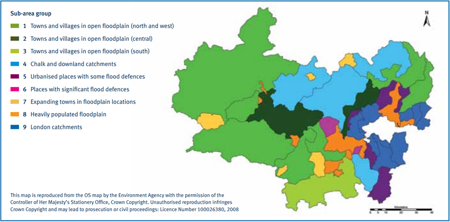
Figure 2-1 Thames CMFP Sub-Area Grouping (Thames CMFP Map)
The Thames CFMP identifies that Kingston may have between 2,000-5,000 properties at risk from a 1% annual exceedance probability fluvial flood. It identifies that these are largely urban catchments, but ones where river corridors have not been over-developed and there is not an over dependence upon flood defence structures. There are opportunities to manage the existing risk effectively and offset some of the impacts of climate change in the future. The approach to flood risk management in these places should use the natural protection already provided by the river channel and the open spaces in the floodplain. The flow of water in the rivers as they pass through built up areas should be maintained and improved. This should be complimented by improvements to other parts of the drainage network.
2.3.4 Thames River Basin Flood Risk Management Plan 2016
The Thames River Basin Flood Risk Management Plan (FRMP) was published in March 2016. The Thames River Basin FRMP is produced in line with the EU Floods Directive (2007), helping to meet the Directive’s requirements for RMAs to produce FRMPs. In the UK, the Directive’s requirements are legislated through the FRR 2009. The documents are updated on a six-yearly basis. They set out how RMAs will work with communities to manage flood and coastal risk over the next six years within the Thames River Basin District. The current cycle runs from 2015 to 2021.
The objectives of the Thames River Basin FRMP are grouped into social, economic, and environmental themes. They outline the main areas where RMAs aim to make improvements. A set of Thames River Basin District-wide measures have been produced to work towards achieving specific objectives. These measures fall under one of four different categories:
- Preventing risk
- Preparing for risk
- Protecting from risk
- Recovery and review
Details on these objectives and measure categories can be viewed in Sections 4 and 8 of Part A of the Thames River Basin FRMP. A new Thames River Basin FRMP is currently in development and is expected to be published by December 2021. Kingston will be involved in this process through the review of existing, and the creation of new, FRMP objectives and measures.
2.3.5 Thames Landscape Strategy
The Thames Landscape Strategy was a report written by Kim Wilkie and originally published in 1994. The report analysed various aspects of the river corridor to help shape future policy, management, projects and design. The report is designed to inform policy and unify decision making along the river corridor, however it is not a statutory document. The area covered in the Thames Landscape Strategy runs from Hampton to Kew. The Strategy covers a number of areas that fall within the Borough including Portsmouth Road, Kingston and Hampton Wick.
A review of the 1994 strategic report was undertaken and published in 2012. The new document takes more recent priorities into account such as those outlined in the climate change and new policy frameworks, including the London Plan. The document provides objectives to work towards the overarching aim of understanding the river landscape and to respecting its character - both natural and man-made aspects. It also provides recommendations for implementation, including those linked to “habitat creation and floodplain restoration” and “land management”.
A Thames Landscape Strategy Action Plan for 2017 to 2020 has been published. It sets out a programme of works up to 2020 in line with the Strategy.
2.3.6 London Sustainable Drainage Action Plan
The London Sustainable Drainage Action Plan (LSDAP) was published in 2016. The Plan aims to address the flood risk challenges posed by London’s increasing population, changing land use, and climate change which places pressure on the city’s drainage and sewer system.
Increased surface water runoff and greater foul water discharges have frequently left the existing drainage systems across London over-utilised. In response, the GLA have produced the LSDAP to help reduce the increasing flood risk. The focus of the Plan is retrofitting sustainable drainage to existing infrastructure, buildings, and land. It looks at opportunities where retrofitting schemes can be implemented at lower costs, and provides money saving measures to local users.
The LSDAP aims to set the direction for the next 20 years. It provides short-term objectives, setting out 40 actions specifically for 2016 to 2021. These actions require the GLA to work in partnership with RMAs including the EA, Thames Water Utilities Ltd. (TWUL), Transport for London and London Boroughs. The actions range from wider policy improvements and delivery of SuDS projects, to the identification of opportunities to better implement SuDS in schools, housing and transport schemes.
2.3.7 South London Waste Plan
The London boroughs of Croydon, Kingston, Merton and Sutton adopted the South London Waste Plan (SLWP) in March 2012, covering the period of 2011 - 2021. A review of the SLWP was completed in 2019 to provide an evidence base to support an updated plan. A revised plan is due to be adopted in 2021 / 2022 to cover the period of 2021 – 2036. The SLWP sets out policies and safeguards sites for waste facilities.
The SLWP review (2019) provides updated advice regarding waste facilities and flood risk, in line with the current NPPF and new London Plan (see Sections 2.2.1 and 2.3.1). Policy WP4, regarding sites for compensatory provision, states that proposals for new waste sites should, “not having an adverse effect on on-site or off-site flood risk. Proposals involving hazardous waste will not be permitted within Flood Zones 3a or 3b.”
Additionally, Policy W6, regarding the sustainable construction of waste facilities, stated that waste facilities will be required to:
“Be fully adapted and resilient to the future impacts of climate change in accordance with the Draft London Plan Policy GG6, particularly with regard to increased flood risk (including ensuring development is safe, does not increase flood risk elsewhere and where possible, reduces flood risk overall), urban heat island/heatwaves, air pollution, drought conditions and impacts on biodiversity.”
The SLWP requires that waste facilities consider and mitigate against flood risk, as reflected in these updated policies. Development of waste facilities will be required to adhere to the boroughs’ waste plans and national flood risk guidance.
2.3.8 River Hogsmill Integrated Urban Drainage DEFRA Pilot Study
The River Hogsmill Integrated Urban Drainage (IUD) Study (2008) aimed to better understand the level of flood risk from all sources within the Hogsmill catchment and identify potential ways of reducing flood risk. The study highlighted the importance of communication between local authorities, developers and partner organisations affected by the River Hogsmill, with increased partnerships resulting in better flood management.
The study recommended that local authorities within the Hogsmill catchment adhere to national requirements (the PPS25 at the time of the study), increase the use of SuDS and retrofit of SuDS at available opportunities. The study created a Flood Risk Tool to facilitate inter-borough partnership and demonstrate the impact of flood mitigation measures within the catchment.
The study highlighted that there are 4,043 properties at risk of flooding from groundwater, sewers, surface water and fluvial sources within Kingston in the Hogsmill Catchment in a 1 in 100 year event. The majority of these properties are at risk of fluvial flooding, with only 4% of the flood risk coming from other sources. It also highlighted that most properties at risk of flooding in the catchment are within Kingston and the benefits that upstream flood management (within Epsom and Ewell Borough Council and Reigate and Banstead Borough Council) has on flood risk within Kingston.
2.4 Local Planning Policy
2.4.1 Local Plan
Kingston’s Local Plan is called the Core Strategy and was adopted in April 2012. It sets out policies and guidance for the development of the borough over the following 15 years, until 2027. A new Local Plan is currently under development to replace the Core Strategy and conform to requirements set out in the NPPF (2019). The new Local Plan is set for adoption in the winter of 2021 / 2022.
The document has a set of strategic visions and objectives that fall under one of the following themes: “A Sustainable Kingston: protecting and enhancing the environment for us and for future generations”, “Prosperous and Inclusive: sharing prosperity and opportunity” or “Safe Healthy and Strong: preventing problems and promoting responsibility and independence”. As per the revised NPPF 2019, Local Plans should take into account the current and future impacts of climate change (see Section 2.2.1 for further details on NPPF requirements).
In recognition of this, Kingston has two Policies under the theme of ‘Sustainable’ regarding climate change. One objective requires high levels of sustainable design and construction to minimise and mitigate against the effects of climate change with regards to carbon dioxide emissions, energy consumption, pollution mitigation and water efficiency. The second promotes and encourages developments to be fully resilient to future impacts of climate change, minimising the risk of flooding, water shortages, subsidence and overheating.
Policy DM 4 of the Core Strategy addresses Water Management and Flood Risk. The policy states that the Council will:
- Require development to be designed to take account of the impacts of climate change including water conservation, the need for summer cooling and increased flood risk from fluvial and surface water flooding.
- Consider development proposals in accordance with national guidance (currently PPS25), the Borough SFRA and related studies including the surface water management plans. The Kingston Town Centre Area Action Plan (K+20) Policy K24 Flood Risk Management will be taken into consideration in the assessment of development proposals within Kingston Town Centre.
- Require a Flood Risk Assessment for major development proposals within Flood Zone 1 of one hectare or more and all new development in Flood Zones 2 and 3. It should address all sources of flooding, the future impact of climate change and take into account the findings of the SFRA, national guidance (currently PPS25) and good practice guidance.
- Require development proposals to include sustainable drainage systems (SuDS) to manage and reduce surface water run-off unless is it can be demonstrated that such measures are not feasible. SuDS techniques include rainwater recycling; soakaways; porous surfacing and features to retain water on site (ponds and green spaces). Development proposals will need to be in line with the Mayor of London's drainage hierarchy. They should also demonstrate that there is adequate public sewerage capacity to serve the development and manage surface water run-off.
- Require development proposals to demonstrate that there is no adverse impact on the quantity or quality of water resources and, where possible, they should seek to improve water quality
- Encourage efficient water use and include water conservation measures in development proposals.
The policy requires developments to be guided to areas with the lowest flood risk in line with current national guidance (the revised NPPF). The NPPF contains further information on the application of the Sequential Test and Exemption Test (Section 6). The NPPF has superseded the PPS25 and should be referenced for current flood risk requirements. The updated NPPF policies are used for the requirements presented in this SFRA.
The Core Strategy introduces flood risk policy for specific town centres and areas of growth. These are presented in Table 2‑1.
Table 2‑1. Town centre specific flood risk policy
Policy KT1: Kingston Town Centre |
|
Promote the use of SuDS in new developments to reduce surface water run-off and apply the findings of the SFRA to reduce flood risk. In addition, the Council will work with partners to mitigate effects in the areas associated with the highest flood risk, which are: Mill Street / Villiers Road area, along the River Hogsmill and Thames Water Sewerage Works, area adjoining Albany Mews, London Road, Gibbon Road. |
Policy MC1: Maldens and Coombe Neighbourhood |
|
Protect open spaces adjoining the Beverley Brook and River Hogsmill Corridor from future development ensuring proposed redevelopment addresses the flood risk associated with Beverley Brook and River Hogsmill and include flood risk mitigation measures. |
Policy SB1: South of the Borough Neighbourhood |
|
Protect open spaces next to the River Hogsmill corridor from future development, ensuring development proposals seek to reduce surface water run-off through the inclusion of SuDS, applying and implementing the recommendations of the borough-wide SFRA and Hogsmill Integrated Urban Drainage Study. Work with partners to identify areas at risk of surface water flooding and develop actions to address these risks and work with partners and residents to mitigate and manage flood risk associated with the Bonesgate Stream and the Tolworth Brook/Surbiton Stream. |
Policy S1: Surbiton Neighbourhood |
|
Ensure that any future development proposals around the River Thames, River Hogsmill and Surbiton Stream / Tolworth Brook incorporate appropriate flood mitigation measures and SuDS. Work in partnership with Thames Water, stakeholders and the local community to ensure that the former Thames Water Filter Beds and the Hogsmill Valley are enhanced to reduce flood risk and made safe for community use whilst taking account of nature conservation interests. |
Policy HV1: Hogsmill Valley Key Area of Change |
|
Seek improved drainage infrastructure in the area to ensure land is capable of productive and beneficial use, reduce flooding by creating a floodplain and ‘naturalising’ the river corridor with additional wetland areas either side. |
Policy T1: Tolworth Key Area of Change |
|
Implement the recommendations of the SFRA, related studies and surface water management plans, working with the Environment Agency, Thames Water and developers to reduce surface water flooding, particularly in the area of the Sunray Estate. |
2.4.2 K+20 Kingston Town Centre Area Action Plan
The K+20 Area Action Plan (AAP) for Kingston Town Centre was published in 2008. The plan sets out a spatial framework to guide development and improvement in Kingston Town Centre. The AAP will be superseded with the adoption of Kingston’s new Local Plan.
The Kingston Town Centre AAP actively plans for growth, manages change and conservation within Kingston Town Centre. The plan includes a range of policies, regarding employment, attractions and facilities, urban design and environmental quality, historic preservation, transport and improving Kingston’s riverside. An SFRA was completed for Kingston Town Centre and was used to inform the flood risk policy in the area. Specifically, Policy 49 states that:
“A detailed flood risk assessment (FRA) will be required for all development proposals within the town centre. This should take account of the advice set out in Kingston town centre Strategic Flood Risk Assessment (SFRA) and include measures to manage and reduce risk of flooding to the site and demonstrate that the development proposal will not increase the risk of flooding elsewhere. Development proposals will be permitted provided they accord with the advice for each flood risk area as set out in the SFRA.”
The Policy advises that developers utilise SFRA Web Mapping to determine what flood mitigation measures may be required at their site to demonstrate future sustainability.
2.4.3 Local Flood Risk Management Strategy
Kingston’s Local Flood Risk Management Strategy (LFRMS) and Action Plan was published in August 2015. The LFRMS was produced in line with the requirements of the FWMA 2010 and National FCERM Strategy. The overarching objective of the document is to better understand, communicate and manage flood risk in Kingston through partnership working. It aims to do this through coordinated approaches for the benefit of all receptors, including property, people, and the environment. The LFRMS sets out Kingston’s approach to limiting the impacts of localised flood risk across the borough. It is a high-level document which sets out four objectives with a set of associated measures for flood risk management. These objectives are:
- Educate, encourage and empower local stakeholders to take action on reducing flood risk.
- Apply an intelligence-led risk-based approach to the management of flood risk in Kingston.
- Establish and maintain collaborative partnerships with key organisations, including Thames Water, neighbouring boroughs and the Environment Agency.
- Use planning powers to encourage sustainable solutions for the management of local flood risk which take account of the likely effects of climate change.
These objectives, their accompanying flood risk management measures and Kingston’s Action Plan have been assessed against Kingston’s Strategic Environment Assessment (SEA) objectives. The SEA demonstrates that the LFRMS should result in positive outcomes for reducing flood risk in the Borough.
Upon the publication of the 2020 National FCERM Strategy (see Section 2.2.5), Kingston will update their LFRMS to align with the themes and objectives of the National FCERM.
2.4.4 Preliminary Flood Risk Assessment
The original Preliminary Flood Risk Assessment (PFRA) was published in May 2011. It was produced in line with the EU Floods Directive 2007 and FRR 2009 requirements, which aims to make flood risk management more consistent across Europe (see Section 2.2.4 for further information). All original PFRAs for London boroughs were written as part of the Drain London project to ensure consistency.
The PFRA is an evaluation of flood risk in Kingston, designed to help inform the strategic management of flood risk in the borough. The Assessment analyses previous significant flood incidents and identifies key flood risk areas. It also analyses future flood risk through undertaking a high-level assessment of the available data flood risk data. This includes information from the EA, TWUL, the London Fire Brigade, Network Rail, London Underground and information held by Kingston.
An Addendum was provided for the PFRA in 2017 following a review of updated flood risk information. Kingston noted that additional flood incidents and updated surface water modelling increased their understanding of flood risk in the area but required no changes. The Addendum identified that part of Kingston is within the Flood Risk Area of Greater London. No other changes were required.
2.4.5 Surface Water Management Plan
The Surface Water Management Plan (SWMP) was published in September 2011, with an update produced in 2019. The document helps LLFAs meet certain requirements outlined in the FRR 2009, as it can provide the evidence base to inform PFRAs and help fulfil the requirement for FRMPs. Kingston’s SWMP (2011) was created as part of the Drain London project to outline the preferred management strategy for surface water runoff for each borough.
The SWMP (2011) describes predicted and historic flooding from various sources which may impact upon surface water flood risk, including sewers, drains, groundwater plus runoff from land, small watercourses and ditches. It is broken down into a four-phase approach: Phase 1 – Preparation; Phase 2 – Risk Assessment; Phase 3 – Options; and Phase 4 – Implementation and Review.
As part of the Risk Assessment phase, the SWMP (2011) defined Critical Drainage Areas (CDAs) for Kingston. CDAs are geographical areas (usually hydrological catchments) where multiple and cumulative sources of flood risk have the potential of causing flooding in one or more Local Flood Risk Zones. The impact of this potential flooding could affect people, property, and local infrastructure. The SWMP identified fourteen CDAs in the Borough:
- CDA 008: Acre Road / North Kingston
- CDA 009: New Maldon North
- CDA 010: Kingston Town Centre
- CDA 011: New Maldon High Street / Coombe Road Rail Crossing
- CDA 012: Surbiton Hill Road / Surbiton Crescent
- CDA 013: London to Woking Rail Link
- CDA 014: Berrylands Alexandra Drive
- CDA 015: A3 Strategic Red Route
- CDA 016: Old Malden
- CDA 017: King George’s Trading Estate
- CDA 018: Hook Kelvin Grove
- CDA 019: Chessington North Station
- CDA 020: Barwell Business Park
- CDA 021: Malden Rushett
The 2019 SWMP update also developed a new process to replace the CDAs designated within the borough. The 2019 SWMP identified flood risk through a catchment and sub-catchment approach, that includes all of the contributing surface area, sewer system and watercourse information that may influence areas of flood risk. This approach mimics the natural environment and is similar to the approach that the EA uses to manage flood risk from main rivers. This approach also provides opportunities for partnership work on flood risk, through the demonstration of how areas located outside of political boundaries affect specific locations.
The SWMP (2019) update revised the approach towards managing flood risk and CDAs within the borough. The SWMP (2019) update collated historic flood information, resident survey information and any hydraulic modelling that has been completed since the 2011 SWMP. This information was used to better understand flood risk within Kingston.As part of the Options phase, the SWMP recommends potential mitigation options that could be incorporated into future CDA flood alleviation schemes. Full details regarding these options can be viewed in Section 4 of the SWMP (2011).
The 2019 SWMP identified five catchments and sixteen sub-catchments. The five catchment areas are:
- Bonesgate Stream
- Surbiton Stream
- Upper Hogsmill River
- Beverly Brook
- Thames and Lower Hogsmill Rivers
Each of the five catchments is further broken down into sub-catchments based on the surface water sewer network. Each sub-catchment represents a distinct contributing area within the wider hydrological catchment. The report highlights potential mitigation options for each sub-catchment that could be incorporated into future flood alleviation schemes in Section 4 of the SWMP (2019).
The 2019 SWMP has not been adopted by Kingston as of May 2021. The adoption of the 2019 SWMP would provide additional information regarding flood risk and potential mitigation options within Kingston.
2.4.6 Climate Change Declaration (Climate Emergency)
In June 2019, Kingston unanimously passed a motion relating to climate change. Subsequently, Kingston has joined a growing number of other Local Authorities who have declared a ‘Climate Change Emergency’ whilst endorsing Parliament’s declaration of a national climate change emergency.
Following the declaration of a ‘Climate Change Emergency’, Kingston has published an Initial Assessment on the climate emergency in November 2019. The purpose of the assessment was to outline the Council’s current approach to carbon reduction and sustainability in operations and the initial actions taken since the declaration of the Climate Emergency.
The Borough has developed a working group to lead their response to climate change. Key points that the Borough aims to address are sustainable transport and travel, air quality, energy efficiency in homes and workspaces, generating and harnessing energy, biodiversity and green spaces, and waste management, recycling and the circular economy. The Initial Assessment does not address flood management, however it does include environmental priorities, including measures to reduce water wastage and river pollution. An additional report is expected to be published to update further actions.
3 Data Sources and Mapping
3.1 Online mapping
The SFRA maps are delivered in a web map format, providing information on the different sources of flooding which impact the borough. The SFRA provides the following four maps:
- Fluvial Flood Risk
- Surface Water Flood Risk
- Groundwater, Sewer and Artificial Flood Risk
- Policy
Appendix A provides information on the data used for the web maps, including details about data origin and key limitations.
4 Applying Climate Change to Risk Assessment
4.1 Overview
The EA published the Adapting to a Changing Climate report in May 2016. The document serves as the second adaptation report under the Climate Change Act 2008. It highlights that weather patterns are changing, with warmer temperatures, heavier rainfall and higher risk of drought shown in weather data. The report references the UK Climate Projections 2009 (UKCP09) which demonstrated the potential future impacts that a changing climate poses. UKCP18 was then released, providing a new set of climate projections for the UK. The projections from UKCP18 are broadly consistent with the UKCP09 projections, however, there are some seasonal and location differences for rainfall and temperature. These projections indicate that severe flooding may happen more often.
In response to growing evidence and climate change projections, Parliament declared a national climate change emergency on 1 May 2019. Following this declaration, Kingston passed a motion to declare a ‘Climate Change Emergency' in June 2019 (see Section 2.4.6 for details).
The NPPF sets out a number of considerations with regards to planning for climate change. It states that:
“Plans should take a proactive approach to mitigating and adapting to climate change, taking into account the long-term implications for flood risk, coastal change, water supply, biodiversity and landscapes, and the risk of overheating from rising temperatures.”
Policies should also support measures to increase community and infrastructure resilience against climate change. It is vital that all risk assessments address the impacts of climate change.
4.2 Climate Change Guidance
4.2.1 Updates
The EA published their current Flood Risk Assessments: Climate Change Allowances guidance in 2016. This updated guidance provides information on how climate change allowances should be applied for SFRAs and site-specific FRAs.
Since 2019, the EA have been revising their Climate Change Allowances to incorporate UKCP18 data. This is ongoing at the time of writing (May 2021), with the most recent amendments being made in July 2020 regarding peak river flow, sea level rise, wind speed, wave height and storm surge. UKCP18 impacts on peak rainfall intensity are currently being assessed by the EA and future revisions the Climate Change Allowances are expected in the future. It is suggested that the outcomes of these peak rainfall revisions are also incorporated into future Local Plan policies and documents once finalised.
UKCP18 builds on the success of the UKCP09, providing an upgrade to the range of climate projection tools available for use. Updates include:
- Up-to-date assessments of how the climate of the UK may change over the 21st century.
- High-resolution spatially coherent future climate projections for the globe at 60km scale and for the UK at 12km scale.
- Downscaling the 12km climate model to a 2.2km scale.
- Marine projections of sea-level rise and storm surge.
Applicants should check the UKCP guidance to ensure the latest information is used as part of any FRAs. The UK Climate Projections: Headline Findings were published in September 2019 and provides details on the key conclusions from UKCP18.
4.2.2 Applying the updated climate change guidance
To correctly apply the latest climate change guidance, it is vital that applicants know the following information:
- The likely lifetime of the proposed development – This is typically 100 years for residential developments and 60 years for commercial developments. Applicants should highlight this in the FRA and are expected to justify why they have adopted a given lifetime for the proposed development.
- The vulnerability classification of the proposed development – See Table 2 of the ‘Flood Risk and Coastal Change’ PPG.
- The epoch period for peak rainfall intensity – See Table 2 of the ‘Flood risk assessments: climate change allowances’. FRAs should assess the ‘central’ and ‘upper end’ allowances to understand the range of impact.
- All FRAs that require peak river flow allowances should use the percentages as seen in Table 1 of the ‘Flood risk assessments: climate change allowances’. Appropriate climate change allowances must be applied. Applicants must consider the flood risk vulnerability classification of their proposed development and the flood zone it falls within.
- The capacity within the development to include required and additional resilience measures to further protect the proposed development against impacts of climate change.
4.3 Adapting to Climate Change
The PPG contains a section on Climate Change. It highlights that addressing climate change is one of the core land use planning principles which the NPPF expects to underpin plan-making and decision-taking. It provides guidance on determining and implementing suitable measures in the planning process to address the potential risks of climate change. The PPG requires:
- Consideration of future climate risks when allocating development sites to ensure risks are understood over the development’s lifetime.
- Consideration of the impact of and promoting design responses to flood risk and coastal change for the lifetime of the development.
- Consideration of the availability of water and water infrastructure for the lifetime of the development and design responses to promote water efficiency and protect water quality.
- Promotion of adaptation approaches in design policies for developments and the public realm.